| |
Advanced Functions
PDF Support
ATLAS.ti's
full native PDF support lets you work with PDF files in their native
layout, just the way you would expect it. No ifs and buts.
Other QDA packages make you strip PDFs down to primitive text files,
which is hardly an adequate way of working, aside from being tedious
and time-consuming to boot. But with ATLAS.ti 6 you are able to keep
your original PDFs untouched—layout, graphics, tables and all—so your
primary data always remains uncorrupted and complete.
Better yet,
you can move freely through your documents and code any section you
like, regardless if it's text or graphics. Smooth scrolling, zooming,
searching and auto-coding make your work a breeze. Navigation tools and
thumbnail images keep you “on track” every step of the way.
Consider the enormous possibilities:
- Work on Web pages saved to PDF, thus securely
maintaining their original layout, graphics, and--most important--all
their actual content at the time of visiting.
- Directly access a plethora of publicly available
resources such as research papers, business reports, conference
proceedings, press releases, and so much more. Now it's all at your
fingertips--without conversion or additional steps of any kind.
- And last but not least, use output from practically
ANY computer application as your primary documents: By creating a PDF
document (via a simple printer driver) you can now directly use
material created in nearly any program, such as PowerPoint, Open
Office, ATLAS.ti itself (!) as well as graphics, statistics, reporting,
authoring, accounting and all sorts of business software as your
primary documents.
Working with PDF Documents in ATLAS.ti 6 PDF
Geo-Coding
Another very exciting feature – and one that is likely to change the way you work – is ATLAS.ti's new geo-coding support.
ATLAS.ti
now embeds Google Earth™ and makes its functionality available from
inside the program. This has immense benefits and opens up phantastic
new possibilities for your work.
Picture, if you will, the world as your ultimate primary document.
Freely move around in it and mark any section that interests you. Then,
treat that segment exactly the way you are used to in ATLAS.ti. Code
it, comment it, and link it to other objects. Use direct hyperlinks
from other primary documents for supporting your arguments and for
purposes of evidence or illustration.

Our
geo-coding facility even creates screenshots from any Google Earth™
view and assigns them as graphical primary documents. This "snapshot"
helps you save system resources and makes sure that your reference is
secured against changes.
All features of Google Earth™ are available (including camera angle and
height over ground). But the interaction between the two programs is
bi-directional, meaning that work done in ATLAS.ti can be directly
introduced into Google Earth™. Comment on a marked location in
ATLAS.ti, and your comment will be displayed in Google Earth™. Powerful
stuff!
And that's still not all: Leverage the immense power of community as
embodied by Google Earth™ layers, and by the possibility to exchange
and directly import Google Earth™'s KMZ files (complex
community-created "overlays"). If it weren't so tacky, we'd call it
"QDA 2.0."
If your work is in or touches on fields such as tourism, geography,
urban planning, ethnology, cultural studies, sociology, health, action
research, advertising and marketing--or even if you simply like to take
and document trips--you are bound to profit from ATLAS.ti's new
geo-coding feature. Like us, you will soon wonder how you used to do
without it.
Working with Geo Data in ATLAS.ti 6 PDF
Text-to-Media-Synchronization
Using "F4" software for transcription purposes? ATLAS.ti 6 now lets you import its transcripts directly.
But why not cut out the middleman altogether? You may find it more convenient to transcribe directly in ATLAS.ti.
ATLAS.ti 6 makes it a breeze to create exact transcriptions from audio
and video files either frame-by-frame by typing along with the
playback, or customizable by linking an existing transcript to the
medium retroactively, i.e. by "striping" it with time code simply by
pressing a key. Of course, it also supports the use of foot switches
and similar controller devices.
For playback, just watch the cursor move smoothly through your text
file in sync with the medium (and vice versa)--either document reacts
directly to the other one. Your segments can be as long or short as you
like.
Oh, and if that isn't enough: It also makes for a great karaoke system.
Text-to-Media Synchronization and Transcription Support in ATLAS.ti 6 PDF
Survey Import
 Imagine
converting the results of a large online survey into a Hermeneutic Unit
in ATLAS.ti with just a few mouse clicks. ATLAS.ti v.6.2 lets you do
just that! Imagine
converting the results of a large online survey into a Hermeneutic Unit
in ATLAS.ti with just a few mouse clicks. ATLAS.ti v.6.2 lets you do
just that!
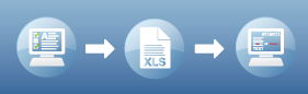
A typical work flow:
- Create an online survey using, for example, Google
Docs (a very convenient tool, although other frameworks are supported
as well)
- Download and store the survey as an Excel table once your respondents have filled out the questionnaire
- Import the table into ATLAS.ti
- Voilŕ: Each row (= one respondent) becomes a primary
document, and content is collected and created from the answers to
open-ended questions. PD families are created from single and
multiple-choice questions; quotations are created for each answer and
coded with the respective question (you may use abbreviations). This
accomplishes a lot of tedious pre-coding work in a few seconds.
Working with the Survey Import in ATLAS.ti 6 PDF
© Copyright 2002-2015 - ATLAS.ti Scientific Software Development GmbH.


|
|